Openness Tool Bathymetric Low
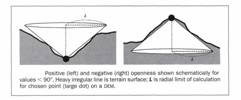
This tool maps bathymetric low features from a bathymetric data using an openness based method [Yokoyama and Pike, 2002]. Smaller positive openness (PO) usually indicates bathymetric low location.
The followings are the key steps of this tool:
Calculate PO from the input bathymetry raster using the Openness Circle Radius parameter
Identify the possible bottoms of the bathymetric low features from the bathymetry raster based on ArcGIS’s Sink function
Calculate the PO threshold by equation (1), where c is the PO STD Scale Large parameter or the PO STD Scale Small parameter, mean_PO and STD_PO are the mean and standard deviation statistics of the PO raster
(1)¶\[PO\_threshold = mean\_PO - c * STD\_PO\]Select the first set of areas that have PO values smaller than the PO STD Scale Large threshold
Select the second set of areas that have PO values smaller than the PO STD Scale Small threshold
Further select from the two sets of areas only those areas that contain bottoms
These two new sets of areas are used together to identify individual bathymetric low features, through GIS overlay and selection analyses
If any polygons in the second set contain more than one polygon in the first set, the multiple polygons from the first set are selected as the first subset
If any polygons in the second set contain only one polygon in the first set, the polygons from the second set are selected as the second subset
Merge the above two subsets of polygons together to form a set of bathymetric low features
Remove the feature polygons with areas smaller than the Area Threshold parameter to obtain the final set of bathymetric low features as output
The openness radius should be large enough to capture the largest bathymetric low features in the dataset. For example, for a 5m resolution bathymetry raster, a radius of 50 cells should be used to capture any bathymetric low features that is smaller than 500m in length. Users should also experiment the PO STD Scale Large, the PO STD Scale Small and the Area Threshold parameters to obtain an optimal output solution.
 1from arcpy import env
 2from arcpy.sa import *
 3arcpy.CheckOutExtension("Spatial")
 4
 5# import the python toolbox
 6arcpy.ImportToolbox("C:/semi_automation_tools/User_Guide/Tools/BathymetricLow.pyt")
 7
 8env.workspace = 'C:/semi_automation_tools/testSampleCode/Gifford.gdb'
 9env.overwriteOutput = True
10
11# specify input and output parameters of the tool
12inBathy = 'gifford_bathy'
13outPO = 'gifford_po10'
14outFeat = 'po10_1_05std_300000m2_BL'
15areaT = '300000 SquareMeters'
16poRadius = 10
17poSTDLarge = 1.0
18poSTDSmall = 0.5
19tempWorkspace = 'C:/Users/u56061/Documents/ArcGIS/Projects/UserGuide/UserGuide.gdb'
20
21# execute the tool
22arcpy.BathymetricLow.Openness_Low_Tool(inBathy,outPO,outFeat,areaT,poRadius,poSTDLarge,poSTDSmall,tempWorkspace)