Add Topographic Attributes Low
This tool add a number of topographic attributes to the input bathymetric low feature class.
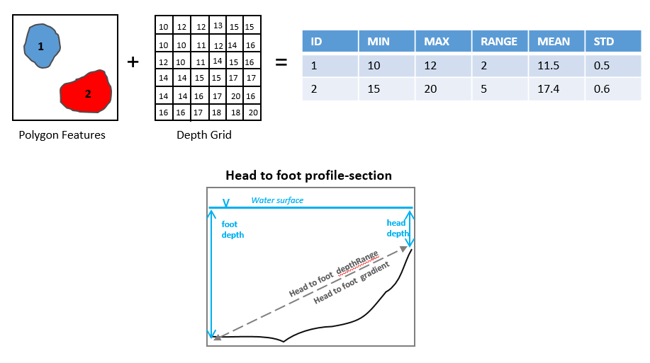
The following attributes are calculated from the bathymetry and slope-gradient rasters to describe the topographic properties of each bathymetric high feature.
headDepth: water depth at the head point of the feature polygon, along the long axis
footDepth: water depth at the foot point of the feature polygon, along the long axis
head_foot_depthRange: the difference in water depth between the head point and the foot point of the feature polygon
head_foot_gradient: the slope-gradient between the head point and the foot point of the feature polygon, which is calculated by equation (1)
(1)¶\[\arctan(\frac{head\_foot\_depthRange}{head\_foot\_length})\]minDepth: the minimum water depth within the feature polygon
maxDepth: the maximum water depth within the feature polygon
depthRange: the difference in water depth within the feature polygon, which is calculated by equation (2)
meanDepth: the mean water depth within the feature polygon
stdDepth: the standard deviation of the water depths within the feature polygon
minGradient: the minimum slope-gradient within the feature polygon
maxGradient: the maximum slope-gradient within the feature polygon
gradientRange: the difference in slope-gradient within the feature polygon, which is calculated by equation (3)
(3)¶\[(maxGradient - minGradient)\]
meanGradient: the mean slope-gradient within the feature polygon
stdGradient: the standard deviation of the slope-gradients within the feature polygon
 1import arcpy
 2from arcpy import env
 3from arcpy.sa import *
 4arcpy.CheckOutExtension("Spatial")
 5
 6# import the python toolbox
 7arcpy.ImportToolbox("C:/semi_automation_tools/User_Guide/Tools/AddAttributes.pyt")
 8
 9env.workspace = 'C:/semi_automation_tools/testSampleCode/Gifford.gdb'
10env.overwriteOutput = True
11
12# specify input and output parameters of the tool
13inFeat = 'test_BL'
14inBathy = 'gifford_bathy'
15inSlope = 'gifford_slope'
16headFeat = 'test_BL_head'
17footFeat = 'test_BL_foot'
18
19# execute the tool
20arcpy.AddAttributes.Add_Topographic_Attributes_Low_Tool(inFeat,inBathy,inSlope,headFeat,footFeat)